
Open house and community meeting at Supervisor District 3 Coastside Offices, September 2023 from PSR-PDS Phase

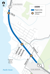
Project area aerial map, Highway 1 Postmile 34.8 to Postmile 35.9
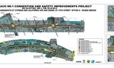
Build Alternative 1 from Environmental Phase with center median, roundabouts at Cypress and California Avenues, signal at 16th Street and bicycle, pedestrian, and bus stop improvements. (Full size image linked in the "Documents and Meeting Materials" section below.)

Build Alternative 2 from Environmental Phase with signals at Cypress Avenue, California Avenue, and 16th Street, and bicycle, pedestrian, and bus stop improvements. (Full size image linked in the "Documents and Meeting Materials" section below.)
Updated: 7/24/2026
The County of San Mateo, San Mateo County Transportation Authority, and Caltrans are continuing to prepare the Project's draft environmental document for public release. The public workshop has been delayed to fall 2026. Check out the videos to get up to speed on the project and what is happening during the current phase; these are under the “Overview” section below.
Sign up at the bottom of the webpage to join the mailing list and stay up to date.
Overview
The County of San Mateo and the San Mateo County Transportation Authority (TA), in cooperation with the California Department of Transportation (Caltrans) have initiated the Moss Beach State Route 1 (SR-1) Congestion and Safety Improvements Project, also known as the “Moss Beach Corridor Project” or “Project." The Project is between 14th Street (Montara) and Marine Boulevard and will modify three major intersections: SR-1/16th Street, SR-1/California Avenue, and SR-1/Cypress Avenue. The Project aims to:
- improve operations and safety for all users at key intersections;
- improve pedestrian and bicycle facilities;
- encourage environmentally friendly transportation options that reduce car trips, such as walking, biking, and public transit; and
- improve vehicular traffic and multimodal connections to coastal resources for both residents and visitors.
To stay aligned with the vision of Connect the Coastside, the project aims to meet the needs of drivers, cyclists, pedestrians, and transit riders, while preserving the character of the coastal community of Moss Beach. There are two options being studied. Improvements may include roundabouts, signals, dedicated turn lanes, high-visibility crosswalks, sidewalks, bus stop enhancements, bicycle and pedestrian path, and bike lanes.
History
For more than a decade, the County of San Mateo has engaged in transportation planning along State Route 1 (SR-1) to identify transportation improvements that meet the unique and complex needs of the County’s Midcoast.
In 2009, the County began an intensive community-based planning process along Highway 1 with the Highway 1 Safety and Mobility Improvement Study. The study engaged citizens in developing short- and long-term transportation improvements to better serve pedestrians and people traveling by car and bike in Miramar, El Granada, and Princeton (Phase 1) and in Moss Beach and Montara (Phase 2). The San Mateo County Board of Supervisors adopted Phase 1 and Phase 2 in 2009 and 2012, respectively.
In 2012, the County received $1.5 million in countywide transportation funds to design and permit these congestion-reducing and safety-enhancing projects. The Highway 1 Congestion and Safety Improvement Project Preliminary Planning Study was completed in 2015, which further defined potential improvements.
In 2021, the TA Board of Directors approved a grant (see Item 11b) to support Project Initiation for the Moss Beach SR-1 Congestion and Safety Improvements Project.
In 2022, the San Mateo County Board of Supervisors adopted Connect the Coastside, a plan that's development identified additional potential improvements in the Moss Beach area to better accommodate future transportation needs.
In 2023, the TA Board of Directors approved a grant (see Item 14b on the December 7, 2023 meeting) to support the Project Approval and Environmental Studies phase of the Moss Beach SR-1 Congestion and Safety Improvements Project.
In 2026, the TA Board of Directors approved a grant (see Item 14a on the January 8, 2026 meeting) to support the Plans, Specifications, and Estimates phase (Project Design) of the Moss Beach SR-1 Congestion and Safety Improvements Project
Engagement
Please join our project mailing list below to stay up to date.
Past
- San Mateo County Bicycle and Pedestrian Advisory Committee, December 18, 2025
- San Mateo County Transportation Authority Board of Directors, December 4, 2025
- San Mateo County Transportation Authority Community Advisory Committee (CAC), December 2, 2025
- C/CAG Bicycle and Pedestrian Advisory Committee, September 25, 2025
- Midcoast Community Council, October 11, 2023
- Presentation and Community Open House, September 19, 2023
- Midcoast Community Council, November 30, 2022
Project Development Phases
The plans referenced in the History section above set the vision and need for improvements in Moss Beach. However, to create a "buildable" project and make changes to highways operated by Caltrans, agencies must follow four project development phases. These phases, described below, will be implemented during the Moss Beach project. For additional details, view the publication How Caltrans Builds Projects. The timeline below describes the earliest possible development of the project, assuming available funding.
Project Initiation (Complete – February 2024)
Project Initiation is the first formal project phase required by Caltrans to move forward with the Moss Beach Highway 1 recommendations identified in Connect the Coastside. During this phase, the project team will establish the purpose and need for the project, study challenges within the project area, identify possible solutions, and estimate the resources needed to complete improvements. Findings from the study are summarized in a Project Initiation Document (PID) and submitted to Caltrans for consideration. A Caltrans' approved PID is required for any major work on the State Highway System and allows the project to be eligible for additional funding.
The Project Initiation phase began in September 2022 and concluded in February 2024. The final product, Project Study Report-Project Development Support, is available under the “Documents and Meeting Materials,” “Technical Reports” section below. This phase was funded by the County of San Mateo and with Measure W funds from the San Mateo County Transportation Authority.
Environmental Studies and Project Approval (Current Phase – 2024 to 2026)
The second step is for the project team to perform preliminary design work and conduct environmental studies to analyze the effect and impact of the project alternatives identified during project initiation. These studies are required by state and federal laws under the California Environmental Quality Act (CEQA) and the National Environmental Policy Act (NEPA). Potential impacts on a range of subjects such as water quality, plants and animals, and transportation are evaluated during this phase.
The studies result in an Environmental Document (ED) which forms the basis for selecting the preferred alternative. The Draft ED is circulated for public comment, after which it is finalized and approved.
The Environmental Studies and Project Approval phase began in summer 2024 and is expected to conclude in 2026. This phase is funded by the County of San Mateo and with Measure W funds from the San Mateo County Transportation Authority.
Project Design and Right-of-Way (2026 to 2028, if funding is secured)
The third step is for the project team to prepare the detailed project design on the approved alternative. This phase is called Plans, Specifications, and Estimates (PS&E). Project information is reviewed and updated, an alternative is selected, and design and engineering reports are generated. Plans for any structures are also prepared. During this phase, any necessary permits and approvals are also coordinated, such as a coastal development permit.
Final right-of-way requirements are determined and procurement is initiated during PS&E. At the completion of the PS&E phase, a complete set of project plans are provided to allow a contractor to bid and build the project.
Construction (2029 to 2031, if funding is secured)
The construction phase of the project entails building the improvements as shown on the plans. The contractor’s work is overseen by construction inspectors and a Caltrans engineer. Care is taken to protect existing resources and minimize impacts during construction.
Timeline

Documents and Meeting Materials
Technical Reports
- Project Study Report-Project Development Support, February 28, 2024
- Engineering and Traffic Survey, February 13, 2024
Factsheets, Flyers, and Noticing Materials
- English Flyer | Spanish Flyer, September 2023
- English Social Media Image | Spanish Social Media Image, September 2023
- Moss Beach SR-1 Congestion and Safety Improvements Project Factsheet, November 2022 - English | Spanish | Multilingual
Presentations and Videos
- Detailed Video with Project Overview and Environmental Phase, January 2026
- Project Summary during Environmental Phase, January 2026
- Build Alternative Details during Environmental Phase, January 2026
- Background on Environmental Phase, January 2026
- San Mateo County Bicycle and Pedestrian Advisory Committee, December 18, 2025 - Presentation
- San Mateo County Transportation Authority Board of Directors, December 4, 2025 – Presentation (Item 11.b, p.378)
- Midcoast Community Council, October 11, 2023 - Presentation
- Presentation and Community Open House, September 19, 2023
- Midcoast Community Council Meeting, November 30, 2022 - Presentation
Maps and Graphics
- Project Area Map
- Project Build Alternative Exhibits Drafts: The exhibits below show draft conceptual designs for the Project as of December 2025.
- Project Build Alternative Drafts: The exhibits below show draft conceptual designs for the Project as of September 2023
- Project Build Alternative Features Board, September 2023 - English | Spanish
- Open House Exhibits, September 2023
Traffic Simulations
The video linked below uses a software program called VISSIM to simulate how Highway 1 would operate for vehicles in the year 2050 without any project improvements and with each of the project build alternatives being considered. Please review the "Project Build Alternative Exhibits" and reference the "Traffic Simulations Handout" while viewing. This simulation was developed for the September 2023 Open House.
- Simulations Video
- Simulations Handout - English | Spanish
Related Studies, Plans, and Policies
- Highway 1 Safety and Mobility Improvement Study - Phase 1, 2009
- Highway 1 Safety and Mobility Improvement Study - Phase 2, 2012
- Highway 1 Congestion and Safety Improvement Project Preliminary Planning Study, 2015
- Connect the Coastside, San Mateo County Midcoast Comprehensive Transportation Management Plan, 2022
- Local Coastal Program, 2021
Funding
Project Initiation Phase Transportation Authority Grant (2021)
Project Approval and Environmental Studies Phase Transportation Authority Grant (2023)
- San Mateo County Board of Supervisor’s Project Support, October 17, 2023
- Presentation to Midcoast Community Council on Moss Beach Project, August 23, 2023
- Midcoast Community Council Letter of Support, August 23, 2023
- Transportation Authority Board of Directors approval, December 7, 2023 (Item 14.b.)
Plans, Specifications and Estimates Phase Transportation Authority Grant (2026)
- San Mateo County Board of Supervisor’s Project Support, September 23, 2025
- Midcoast Community Council Letter of Support, September 2025
- Transportation Authority Board of Directors approval, January 8, 2026 (Item 14.a.)
Contact Us
Send us a question or comment.
Chanda Singh, Senior Transportation Planner, County of San Mateo
Lilliana Price, Project Manager, San Mateo County Transportation Authority