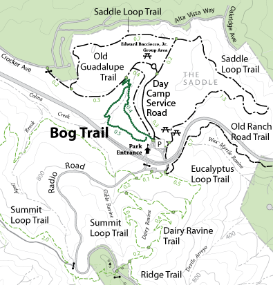


The Bog Trail winds through San Bruno Mountain Park's "Saddle Area," a wet, riparian area at the foot of the mountain. The chilly Pacific air here rumbles with the wash of jets departing SFO. It's often foggy or cloudy, with a breeze blowing off the ocean. A dense, low canopy of sedge and rush hedges most of the trail, while cool leather ferns grow in the shadier nooks. Many birds--wrens, finches, sparrows, and more--can be heard singing. You may even spot a covey of California quail scampering beneath the brushwood.
The trail begins a short distance west of the parking lot. At the trail head you'll find two paths, both marked "Bog Trail." Bog Trail is a loop that connects back with itself at the trail head, so you may travel either path and end up right back where you started. The trail straight ahead is broad, gravelly, and well-manicured, while the trail to the left offers a little more adventure.
The visitor who follows the trail straight ahead will be treated to a leisurely walk. Benches at regular intervals offer a place to sit and rest, though with an elevation gain of only thirty feet you might not even need them. The trail continues for 0.4 miles, eventually finding its way to a grassy portion of Colma Creek. Just over the wooden bridge that spans the creek you reach a fork in the trail.
The well-manicured leg of Bog Trail ends here. Old Guadelupe Trail, a broad gravelly path, continues uphill to the right. To the left begins the second leg of the Bog Trail loop. This leg is where the Bog Trail earns its name. With a little rain this becomes the "muddy leg" of the Bog Trail loop (picture actual muddy legs). The trail narrows. There are mossy branches to duck under, and inclines to navigate (not too steep). Unlike the first leg, there's not a bench in sight. Halfway along the second leg you encounter another wooden bridge. Here the creek has widened and flows faster, through mossy stickbrush rather than grass. A bit farther and you're back at the trail head where you began.
Trail Elevation Change
Upper Leg: 33 ft. (See Elevation Profile), Lower Leg: 108 ft. (See Elevation Profile)
Open to: Hiking
Surface:Gravel, Soil
Length:
