San Mateo County Parks is happy to announce that our parks and trails are now featured on the free OuterSpatial app. The app provides easily accessible information to help plan your visit! Because the app uses offline mapping and navigation, you can use it even when cell service is not accessible. This new service is possible thanks to the financial support of our non-profit partner, the San Mateo County Parks Foundation.
You can use OuterSpatial to:
- Discover new places
- Navigate while on trail
- Locate parking, restrooms, drinking water, picnic areas and other amenities
- Learn more about your local parks through the “Outings”
- Receive notifications about hazards, closures and other timely information
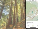
Follow the map instructions below to locate yourself on the map while you're out on the trail, even when you are offline. OuterSpatial also provides access to maps and info from many other park agencies in our region.
Map Instructions
A little bit of set up is necessary before you’re at the park to make sure you have the map you need while out on the trail when cell coverage is often not available:
- Open the OuterSpatial app on your phone or tablet.
- Click Explore to find the park that you want to visit by using the search bar or clicking the area icon on the interactive map.
- Click on the selected park tile and scroll down to the Map Gallery section to open the Paper Map link.
- Zoom in on the map–once you can clearly read the trail names the paper map has loaded to your device.
When you’re at the park just re-open the map and click the arrow button (upper-right). The app will use GPS to center the map on your location, shown as a blue dot, which works even when you do not have cell coverage or WiFi.