Updated: 01/14/2026
Updates
01/14/26 Update
The community meeting to discuss the findings of the Seal Cove Geologic Study has been scheduled as follows:
- Date: February 18, 2026
- Time: 6:00 PM
- Location: District 3 Coastside Office, 270 Capistrano Rd., Suite 6, Half Moon Bay
12/15/25 Update
The Seal Cove Geologic Study is now available for public review. A community meeting to discuss the report will be held in January, the date of which will be announced soon.
08/14/2025 Update:
An independent geotechnical study is under way by Cotton, Shires and Associates, a firm specializing in geological hazards. The report will provide a technical basis for understanding current conditions and exploring potential responses. The updated geologic assessment is expected to be available for public review by mid-September.
A community meeting to present and discuss the findings and recommendations will be held in the Office of Supervisor Ray Mueller, 270 Capistrano Road, in the near future. The professionals who prepared the report will be present to share their work and answer questions.
The purpose of this page is to provide information regarding the recent increase in the rate of landslide movement occurring in the Seal Cove Area of Moss Beach, and to inform the community about the actions being taken by the County to assess the situation and to minimize and address the impacts it is having on the homes and roads in the area.* The County’s chief priority is to protect the health and safety of Seal Cove residents and members of the public in the area.
The County is focusing its efforts on:
Identifying the homes that have been impacted by soil movement, and working with the affected homeowners to take appropriate action;
The Building Division of the County Planning and Building Department has been performing visual inspections of impacted properties to determine if and how the use of these homes needs to be restricted. The Building Office is in the process of contacting all such affected homeowners individually to discuss these restrictions and any necessary remedial work. If you do not receive notification from the Building Office regarding the potential issuance of a yellow or red tag, it is because your property has not been identified as being at immediate risk from the land conditions based on what can be seen from the public right-of-way. Due to the limited ability of County staff to identify potential problems based on visual inspections from the local roadways, it is possible that some homes that are at risk may not be contacted by the Planning and Building Department. Therefore, property owners who believe there home has been impacted or may be at risk are strongly encouraged to contact the Building division at (650) 599-7311 or buildinginspections@smcgov.org to arrange for an inspection, and to work with qualified professionals to perform a risk assessment and evaluate what actions may be need to ensure the safety of its occupants.
Monitoring damage to the local roadway network, maintaining, and evaluating options to either repair or restrict use of these roads;
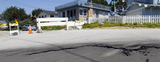
County Public Works personnel from the Roads Division have been inspecting road conditions in the Seal Cove area to evaluate the need for any immediate measures that can be taken to maintain the County roads and ensure the continued use by the traveling public. You may have observed that San Lucas Avenue at Ocean Boulevard has been closed to traffic since March 2023 and at Del Mar Avenue has been closed to traffic since January 2025 due to the significant and differential movement of the roadway. Additionally, cracks in the pavement have developed on La Grande Avenue west of San Ramon Avenue. Public Works staff previously placed paint markings on San Lucas Avenue and recently placed paint markings on the pavement of La Grande Avenue, generally straddling the existing pavement cracks, for their use as reference points to monitor and record roadway movement and changes in the crack widths. The markings on La Grande Avenue have been labeled on the pavement as Zones A, B, and C. While we do not plan to implement any additional road access restrictions at this time, including on La Grande Avenue, our County Roads crews will continue to evaluate road conditions particularly in light of any additional ground movement that may occur. Urgent road conditions can be reported on-line or by calling (650) 363-4103.
Updating the geologic study developed in the 1980’s to inform the County’s Local Coastal Program policies and regulations governing Seal Cove development;
While the geotechnical studies have documented hazards and unstable conditions in the Seal Cove area for more than fifty years, land movement appears to have accelerated in recent months, indicating the need for updated analyses to inform the decisions of residents, land use agencies, utilities, and other stakeholders.
Accordingly, the County is in the process of contracting with a professional geologic assessment team to comprehensively study the area's geotechnical conditions. The study will provide an updated assessment of the various geologic hazards affecting the community and recommendations on how to manage development and infrastructure strategically. It is expected that the study will take approximately two months to complete. After completion, the county will share the final report with the public.
Coordinating with MWSD about necessary repairs to water and sewer lines.
The County is aware that the Montara Water and Sanitary District (MWSD) has been actively responding to leaks and other infrastructure impacts of recent land movement in the area. County staff from the Departments of Public Works and Planning and Building have been in close contact with MWSD staff to report any impacts to MWSD infrastructure observed by County crews and to provide assistance, such as issuing emergency encroachment permits, to allow MWSD to perform emergency repairs. Contact MWSD for more information.
Resources
* Impacts to water and sewer infrastructure are being addressed by the Montara Water and Sanitary District (MWSD). Information regarding the actions being taken by MWSD is available at Seal Cove Critical Geotechnical Hazards Area Resident Updates | Montara Water & Sanitary District.