Redwood City – As wildfires rage and the drought parches Northern California, first responders urge San Mateo County residents to learn a short code that can save lives in an emergency.
First responders will use the code to direct evacuations or issue shelter-in-place orders for specific zones across the Peninsula. With lessons learned from last year’s CZU Lightning Complex fire, local officials are promoting a “Know Your Zone” campaign as summer heat bakes the state.
Know Your Zone – Here’s how it works:
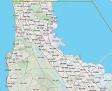
Emergency managers have carved the Peninsula into more than 300 zones on an online, publicly available map supported by Zonehaven, a California-based company under contract with the County of San Mateo. Each zone is assigned a short code. All residents can enter an address to find their zone.
“When it comes to emergency response, every minute counts. Zonehaven gives emergency responders the ability to form hyperlocal evacuation plans quickly and collaboratively, which can be shared with the public immediately.”
Supervisor Don Horsley
For example: “SMC-E001” is roughly the San Mateo Highlands, “MP-E008” is roughly Menlo Park’s Belle Haven and “DC-E004” is an area of Daly City snug with San Francisco.
Why roughly? The zones may not follow traditional neighborhood or even city borders. Instead, the zones are optimized for best evacuation routes and other factors and eliminate confusion about arbitrary boundaries.
In an emergency, first responders will issue evacuation or other orders and advisories based on the zones. This information will be pushed out via the news media, social media such as Twitter, emergency alert notifications and other platforms.
“When it comes to emergency response, every minute counts,” said San Mateo County Supervisor Don Horsley, whose District 3 includes the coast from Pacifica to the Santa Cruz County border. “Zonehaven gives emergency responders the ability to form hyperlocal evacuation plans quickly and collaboratively, which can be shared with the public immediately.”
The Zonehaven platform can also be updated quickly with the location of emergency shelters and other vital information in an emergency.
Emergency officials say last year’s CZU Lightning Complex fire – the largest and most damaging fire in the county’s recorded history – and the early start to the 2021 fire season highlight the need for all residents to “Know Your Zone.”
“Zonehaven was vital for quickly and accurately implementing and managing evacuations in San Mateo County during the CZU Lighting Complex,” said Jonathan Cox, CAL FIRE division chief for San Mateo County. “This online platform is a technological leap forward that allows us to instantaneously and directly communicate real-time evacuation information to the public, and in turn helps to get people to safety faster.”
“Zonehaven was vital for quickly and accurately implementing and managing evacuations in San Mateo County during the CZU Lighting Complex.
CAL FIRE's Jonathan Cox
What you can do today:
All San Mateo County residents are urged to look up their zone for their home, work and school and to write the zones down where the codes are easily found.
In the event of an emergency, the Zonehaven platform will be updated with real-time evacuation routes and other information. Fire departments and other first-responding agencies across the county will update the platform so evacuation routes and other information is timely and localized.
Relevant additional data is fed into the map, showing risks over zones, such as the incident location, wind speeds and directions. The Zonehaven platform is a digital application that can be accessed on a smartphone, computer or tablet, and interfaces with real-time GPS-guided traffic maps available through applications such as Waze.
Residents are encouraged to follow their local emergency responders on real-time social media platforms and to sign up for SMC Alert, a free service that sends emergency and non-emergency text and voice messages to:
► Email accounts
► Cell phones, smartphones, tablets
► Landline phones, home and work
“Now is the time, before an emergency, to take a few minutes to look up your zone and sign up for emergency alert notifications,” said Charlie Crocker, Zonehaven’s chief executive officer. “We can provide the tool but it’s up to everyone to get prepared. Here in California we face the constant threat of wildfires, floods and earthquakes. So let’s all take a moment to get prepared the best we can.”
Learn More
Sept. 18, 2021: Disaster Preparedness Day
Prepare for an Emergency: Tips from the Department of Emergency Management
Media Inquiries: Contact Michelle Durand, chief communications officer, at Mdurand@smcgov.org